

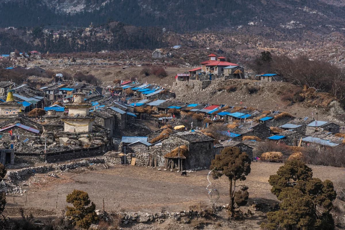
Samagaon is not simply another location along the Manaslu Circuit Trek route; it is the stage at which the pace slows down, the body has to listen, and the culture of the upper Budhi Gandaki valley becomes evident. The majority of the trekkers reach this place on the sixth or seventh day of their journey, with legs tired and breathing being more challenging than when they first started the expedition. Samagaon is located 3,530 meters (11,581 feet) above sea level, making it the highest large settlement within the area. In addition, this village is the last location that possesses some infrastructure prior to ascending to Samdo, Dharamsala, and Larkya La Pass at an altitude of 5,106 meters (16,752 feet).
Where Is Samagaon and How High Is It?
Samagaon is situated in Chumanuwri (Chum Nubri) Rural Municipality within Gorkha District of Gandaki Province of Nepal. The geographical location of Samagaon can be found at 28.58°N latitude and 84.64°E longitude, near the Tibetan border, directly under the southern slopes of Mount Manaslu (8,163 meters / 26,781 feet), the eighth highest peak in the world.
The altitude is generally reported to be 3,530 meters (11,581 feet). There have been other reports stating the altitude range between 3,530 meters and 3,800 meters, depending on whether you include the hamlets and grazing areas. In case of trekking, however, 3,530 meters is the altitude you need to know about. This is the altitude at which your teahouses are located, where your acclimatization day takes place, and you spend two nights.

View of Mount Manaslu seen from Samagaon Village
Samagaon is the biggest village on the upper circuit route. There were 665 people in 179 households during the census conducted in 1991. A recent population figure states that there are 604 people living in the village. Samagaon is a purely Buddhist village where there is a very distinct Nubri Tibetan culture. Prayers flags are present on the ridges. The paths are bordered by mani walls. Juniper smoke can be smelled in the evening. This is not a tourist village which just falls on the trekking route but a real Nubri village which trekkers traverse through.
Getting to Samagaon on the Manaslu Circuit Trek
Very few people visit Samagaon straightaway. The village can be reached only via foot and the journey will begin from either Machha Khola or Soti Khola. Beginning from Machha Khola which is about 930 meters or 3,051 feet, the route goes along the Budhi Gandaki River to Jagat, Deng, Namrung, Lho, Shyala, and Samagaon.
For the 14-day itinerary, the schedule puts Samagaon at the fifth or sixth day according to the place from where the trip started and divided the days. The walking from Namrung which is 2,630 meters or 8,629 feet to Samagaon is around 19 kilometers (11.8 miles) and would take six to seven hours. It will go through Lho at 3,180 meters or 10,433 feet and Shyala at 3,500 meters or 11,483 feet from where one gets views of Manaslu.
Trail conditions are moderate. They include crossing rivers, going through forests and open valleys. The increase in elevation is gradual but tough. When you get to Samagaon, you would have moved up from the subtropical canyon at Machha Khola to the boundary of the high alpine region. This is one of the most enjoyable parts of the Manaslu Circuit trekking route.
Culture, History and Lifestyle of Samagaon
Samagaon is a Nubri village. The Nubri ethnic group is an ethnic Tibetan group whose language is also close to Tibetan dialects spoken over the border in Tibet. They practice Tibetan Buddhism and speak Nubri which is close to the languages spoken by the Tibetans. Their dressing style, food, and buildings depict their history of living for many years in high altitudes in a valley connecting Nepal and Tibet.
The village has a rich history as a trading place. Before tourism started there, Samagaon used to be a trading post on the route of salt and grains trade between Tibet and the valleys in lower Nepal. The trade was made possible by the yaks carrying goods from the Larke La Pass to the valley of the Budhi Gandaki River.

Buddha Chorten on the way to Samagaon village
Religion is an integral part of everyday life here. There is a monastery in the village, and the landscape around it has chortens, mani walls, and prayer flags. Pungyen Gompa is an ancient monastery above Samagaon, and it is considered one of the oldest places of worship in the upper region. Its origins are connected with the mountain itself.
The local way of life is based on agriculture and livestock. Farmers cultivate potatoes, barley, and buckwheat in small fields near the village. Yaks and dzo are kept on the pastures in the mountains nearby. There is a development of teahouse tourism, but it does not substitute the previous economic activities. The fields continue to be cultivated. Yaks continue to be herded. Monks are visited by villagers during festivities.
Samagaon to Samdo Distance and Walking Time
The trek from Samagaon to Samdo is quite short as well. It is 8 kilometers long (5 miles), and can be completed in 3 to 4 hours. The altitude gain during this hike is relatively small as the difference between 3,530 meters (11,581 feet) and 3,860 meters (12,664 feet) is not very big.
The route goes upstream along the Budhi Gandaki valley and crosses Birendra Lake, which is situated just a bit off the trail. There are many trekking parties that visit the lake while heading towards Samdo and not separately. Then the path goes across the open valley area until Samdo, another village closer to the Tibetan border.
Samdo is smaller and windier than Samagaon. Its altitude is 3,860 meters (12,664 feet). Teahouses are rather poor. Usually, most of the trekkers spend only one day in Samdo before moving further to Dharamsala (4,460 meters / 14,633 feet) and then over the pass.
The relatively short walk from Samagaon to Samdo is deliberately done. It is part of the process of acclimatization. Your body will ascend slowly, and you will sleep at a slightly higher altitude compared to where you slept the previous night.
Samagaon to Manaslu Base Camp
The trek to Manaslu Base Camp is the primary acclimatization process in Samagaon. The trek is a day trek and not a multi-day trek where one hikes up high, stays there for some time, and comes down to sleep at lower altitudes. This is the recommended pattern of the acclimatization process.
The distance covered during the trek ranges from 12 to 15 kilometers (7.5 to 9.3 miles). It takes seven to nine hours to complete. The total ascent is about 1,270 to 1,300 meters (4,167 to 4,265 feet). One starts trekking from 3,530 meters (11,581 feet) and ends the trek at Manaslu Base Camp at 4,800 meters (15,748 feet).
The trail is simple in terms of climbing. There are no technical aspects of climbing involved. No rock climbing or scrambling is involved in the trek. However, the trek is tough due to the altitude. The oxygen present at the altitude of 4,800 meters is less than half of that available at sea level.
This trekking path goes through the moraines of the Manaslu Glacier. You will pass by glacial lakes, ice faces, and avalanche debris. The view of the south face of Manaslu is breathtaking. Base Camp is a series of tents and stone huts used by the members of expeditions. For trekkers, base camp is the place where you can sit, drink, take photos, and begin your descent towards Samagaon.
Samagaon to Birendra Lake Distance and Walking Time
Birendra Lake, also known as Birendra Tal, lies at an altitude of 3,691 meters (12,110 feet), some three kilometers (1.9 miles) to the north of Samagaon. The climb from the village itself is quite low, at approximately 160 meters (525 feet). It will take you 45 minutes to one and a half hours to reach it.
It is a glacial lake, formed by the Manaslu Glacier. It is of turquoise blue color due to the presence of rock flour in its waters. This color is diluted after the rains due to sediment. The lake is situated behind a moraine dam. In April 2024, the lake experienced a flood due to an ice avalanche, and it is still considered hazardous by researchers.

Birendra Lake, a perfect acclimatization hike from Samagaon
As a trekking destination, Birendra Lake is easily reachable within half a day. As it lies aside the major trail, the lake is usually visited together with Samdo. The lake is holy for the Nubri people. The area around the lake is covered with prayer flags. Respect is due to the place as any other monastery.
Samagaon to Pungyen Gompa
Pungyen Gompa is another major side-trip from Samagaon. The gompa is located at an elevation of 4,000 meters (13,123 feet), situated on a plateau that overlooks the village. The return trip takes five to seven hours, including four hours climbing up and two to three hours descending down.
It is believed that the monastery is about 400 years old, with its history being linked to the mountain itself. As reported in 1954, a Japanese expedition approached Manaslu, but it was prevented by the locals because the previous expedition had somehow offended the deities of the mountain, and the punishment of the locals came through an avalanche that buried Pungyen Gompa under debris, killing eighteen people. After leaving the area, the Japanese expedition helped rebuild the monastery. Finally, in 1956, a Japanese mountaineer together with a Sherpa became the first ones to ascend Manaslu.
The trek to Pungyen Gompa is a quiet trail compared to that of the base camp path. The path diverges from the main circuit, winding up the hillsides. The gompa is a lonely building situated on an expansive plateau. The views of the mountain ranges, especially that of Manaslu, are great. It is a different form of an acclimatization trek; it is more about being at the altitude for some time.
Mountain Views and Landscapes Around Samagaon
Samagaon lies immediately below Manaslu. The mountains dominate the scenery from almost any teahouse. Early mornings find the summit catching the sunlight before the village. Evening sees the last light on the glacier and the mountains rising above.
The environment is glacial and high alpine. The Manaslu Glacier flows from the summit, ending in a moraine which extends past Birendra Lake. There are great views opening up around Samagaon towards Samdo and the Larke La Pass. The peaks of Himalchuli and Ngadi Chuli are seen to the east and south.
Good photos can be taken here. The light is excellent in autumn and spring. The mountain scenery is unobstructed. There are cultural scenes including the stone buildings, prayer flags, and mani walls of the village. Photography of people should be done with permission. Drone flying is forbidden.
Accommodation and Facilities in Samagaon
Samagaon has the most developed teahouse facilities on Manaslu circuit. There are about eight to ten lodging establishments, including a number of key ones that are frequently used by trekkers. Samagaon Lodge is frequently referred to as one of the most trustworthy ones. Tibet Guest House and Norbu Guest House are also popular among visitors.
The accommodations are modest yet clean. Most of the rooms are twin-share. Some teahouses have ensuite rooms, which is quite uncommon at such an elevation. Rooms have mattresses and blankets, but you will need a sleeping bag too. Dining facilities have wood-burning stoves, making the place the center of all social activities in the evening.
Teahouses in Samagaon provide a more diverse menu than those above. You can enjoy fresh vegetables, egg dishes, and apple pie in Samagaon, which cannot be found at higher elevations. This is the last place where you will be able to enjoy such variety in your menu.
Food and Drinking Water
The food provided in Samagaon is quite typical for any teahouse. Dal bhat is the main food there. Tibetan food such as thukpa and momos is also present. There are noodles, soups, and egg-based dishes on the menu. The portions are rather big, and the food is fresh.
There is drinking water in the area. Teahouses provide boiled and bottled water. It is rather costly and bad for the environment. The best solution would be to bring the water filtration system with you and get water either from the tap or from the stream. Boiling is reliable. Chemicals work as well. Filters alone are not sufficient in Nepal.
Toilets, Showers, Electricity and Wi-Fi
Most teahouses have shared squat toilets. Lodges in Samagaon have better facilities including Western-style toilets, which is rare in the teahouse trekking experience. Carry toilet paper and hand sanitizer.
Hot showers are available at an additional cost. They use either solar heating or wood fire. The rate for a shower is NPR 300 to 500 (USD 2.50 to 4). You need to pay to enjoy a hot shower at this altitude, although it will take a short time.
The electricity source is solar. Charging is done in the dining area at an additional cost. To charge a phone, you pay NPR 200 to 400 (USD 1.50 to 3). A power bank is more expensive. The electricity can be unstable in cloudy weather. Get a 20,000 mAh power bank.
Wi-Fi is available at some teahouses with an internet charge. The speed is very poor. One cannot stream videos or make any video call from here. There is partial mobile coverage. NTC covers some parts of the village. Ncell's coverage is poor. Once one goes above Samagaon, there will be no mobile coverage at all.
Weather and Temperature in Samagaon
The weather in Samagaon is alpine. The weather pattern here changes abruptly. Mornings remain sunny, while afternoons are cloudy and windy. It may snow at any time in a year.
During autumn season that lasts from late September to November, temperature during the day remains around 10°C (50°F), whereas nighttime temperature goes down to -5°C (23°F). October remains the clear month of the season, while November is colder but trekable.
The spring season from March to May shows almost similar but milder weather. Ideal weather conditions can be found in April and early May months. Rhododendrons bloom during the season in lower valleys, while Samagaon lies above the rhododendron zone.
Monsoon period from June to August brings rains and clouds. The route turns muddy. Landslides occur in the lower gorges. Visibility is low. Trekkers try to avoid this season.
Winter that comes from December to February is severe. Snow covers the Larkya La Pass, and teahouses above Samagaon shut down. Only expedition groups and some tough trekkers undertake the circuit.
Acclimatization and Altitude Sickness in Samagaon
Samagaon serves as the most crucial acclimatization point on the Manaslu Circuit trek. Most trekkers are given a day off in Samagaon, and this is not an option. Those who do not take a break in Samagaon face trouble crossing the pass.
The facts are simple and clear. At an elevation of 3,530 meters (11,581 feet), there is only about 35% oxygen available compared to sea level. To carry out oxygen in the best way possible, the body requires time to build up new red blood cells. This is not something that can be done instantly.

Bell ringing Chorten in Samagaon, Manaslu
The symptoms of altitude sickness include headache, nausea, dizziness, exhaustion, and even breathlessness while resting. If the symptoms get worse, you need to start your descent. Descending by 500 to 1,000 meters (1,640 to 3,280 feet) normally helps.
Climb high and sleep low is the best acclimatization technique. You should ascend to Manaslu Base Camp or Pungyen Gompa during the day. Go back to Samagaon for your night’s rest. You should drink three to four liters of water per day. You should eat adequately, despite poor appetite. Avoid alcohol consumption. You may consider taking Diamox if your doctor advises you to do so.
Things to Do and Places to Visit Around Samagaon
Manaslu Base Camp Hike: The major acclimatization hike. 12 to 15 kilometers one way. Seven to nine hours. It ascends to 4,800 meters.
Birendra Lake: Walk to the glacial lake. 45 minutes to 1.5 hours one way. Simple and beautiful walk.
Pungyen Gompa: Monastery situated at an altitude of 4,000 meters. Five to seven hours roundtrip. Less frequented than the base camp hike.
Nearby Villages: Village Samdo is accessible within a short walk. Villages of Lho and Shyala can be found on the trail below Samagaon. Each village has its own uniqueness.
Exploring the Villages: Take a stroll through the village of Samagaon. Visit the monastery and photograph the mani walls. Have tea in a teahouse and observe the villagers’ life.
Best Time to Visit Samagaon
Autumn, ranging from late September to November, is the best time to visit Samagaon. The sky is clear. Views of the mountains are clearer. The trails are dry. October is the best month. November is colder but less crowded.
Spring, ranging from March to May, is the second-best choice. In April, there is good weather with warm temperatures. The valleys are lush.
Winter and monsoon seasons are possible but not advisable. Monsoon brings rain and fog. Winter brings snow and cold.
How Long Should You Stay in Samagaon?
A stay of two nights is the norm. You arrive in the afternoon, rest, spend the next day on the acclimatization hike, rest once again, and depart on the next morning. That way you give yourself two nights at 3,530 meters and one day of ascending to even greater altitudes.
Some trekkers will stay for three nights in case of feeling the effect of the high altitude. Some will continue after spending only one night because of good acclimatization. Your choice must be guided by how you feel, rather than by the itinerary. In case of having a headache that does not stop, stay for another day.
Common Challenges of Staying and Trekking Around Samagaon
Elevation: The biggest obstacle. Simple chores become difficult.
Temperature: It’s cold at night. Teahouses don’t have good heating. Pack warm clothes.
Toilets & Hot Water: There are shared toilet facilities. Hot water and power aren’t dependable.
Internet Connectivity: The Wi-Fi connection isn’t very fast. Mobile coverage is poor.
Walking Days: Side hikes are strenuous.
Variable Weather: Weather conditions change frequently.
Safety Tips for Samagaon
Take your acclimatization day seriously.
Consume three to four liters of water per day.
Do not walk too quickly. There is no hurry.
Eat properly even when you do not feel hungry.
Do not drink alcohol at altitude.
Be aware of signs of altitude sickness.
Descend if symptoms get worse.
Have a satellite messenger in case of emergencies.
Let someone know about your plans.
Check weather conditions before hiking.
Why Is Samagaon an Important Stop on the Manaslu Circuit Trek?
There are three main reasons why this village exists. First, it is an acclimatization spot. It is located at an appropriate elevation with appropriate facilities in order to get ready for ascending to even higher areas. Second, it is a cultural area.
The village, the monastery, the mani walls, and the daily life of the locals provide you with an opportunity to get familiar with the lifestyle of this area, which is hundreds of years old.
Third, it is the starting point for all the side excursions of the circuit: Manaslu Base Camp, Birendra Lake, and Pungyen Gompa.
Samagaon is what makes the Manaslu Circuit unique. Without it, the trekking route would be shorter, less cultural, and much more dangerous.
Final Thoughts
Samagaon is where the Manaslu Circuit requires you to take your time. You cannot rush through Samagaon. It will not allow you to due to the altitude, weather, and simply because there is too much that needs to be seen and experienced in this village.
For most trekkers, the main memory associated with Samagaon is the rest day spent there. The journey to the base camp and the mountain views during the trek will come up as well. However, the deep-rooted memory will be associated with something very simple. It will be associated with the sounds made by prayer flags when blowing in the wind, the thukpa bowl consumed at the end of the day and a conversation with a lodge owner who has lived there their entire life and cannot think of anything better.
This village is situated at the foot of the high mountains and has been there for centuries. Trekkers come and go, seasons change, yaks continue grazing and the monastery stays standing. Samagaon has never been built for the purpose of the trekking route.
Plan Your Manaslu Circuit Trek With Us
Are you considering undertaking a Manaslu Circuit Trek in 2026? Shoot us a message via WhatsApp at +977-9851042334, and we would love to assist you in arranging the trek according to your itinerary and health status.