
Nepal’s Mystical Highlands
Dolpo, a region that covers 5.36% of the total landmass of the country, is the largest district in Nepal. Surrounded by majestic peaks like the Annapurna and the Dhaulagiri, this region is bound to give travelers a memorable adventure while traveling through its mystical highlands.
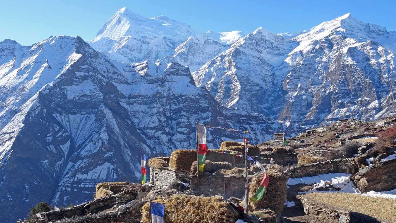
Also known as the land behind the Himalayas, the snow-clad peaks cast a shadow on the region making it a rain-shadow area, perfect for visiting throughout the year. This rugged beauty lets you hear the whisper of the legends, truly a land where time stands still and is protected by its remoteness.
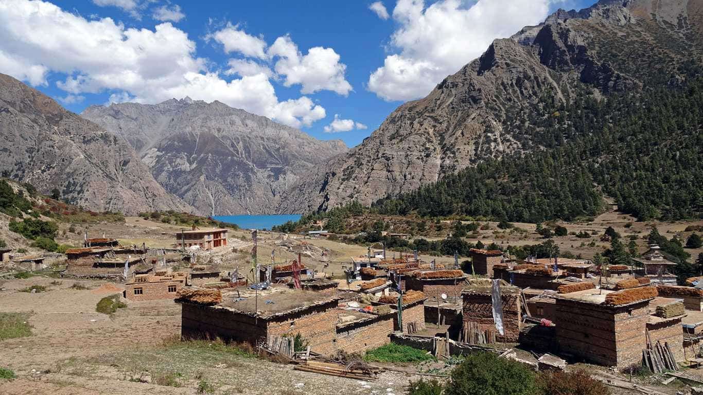
While traveling through the Upper Dolpo region, travelers will be able to connect with the mystical energy of this region while passing through its snow-capped mountains, deep valleys, and deserts. Similarly, in the case of the Lower Dolpo region, travelers will be able to enjoy the view of the beautiful Phoksundo Lake while also passing through green forests and remote villages.


Tapestry Of Ancient Culture And Traditions
Dolpo has been able to preserve its culture and traditions by the tides of time. Culture-wise, Dolpo is divided into three parts: Upper Dolpo, Tichirong (Middle Dolpo), and Lower Belt. The inhabitants are known as Dolpo-Pa. They are the true custodians of their rich and unique traditions, and although diversified by region, they remain a true testament to perseverance.
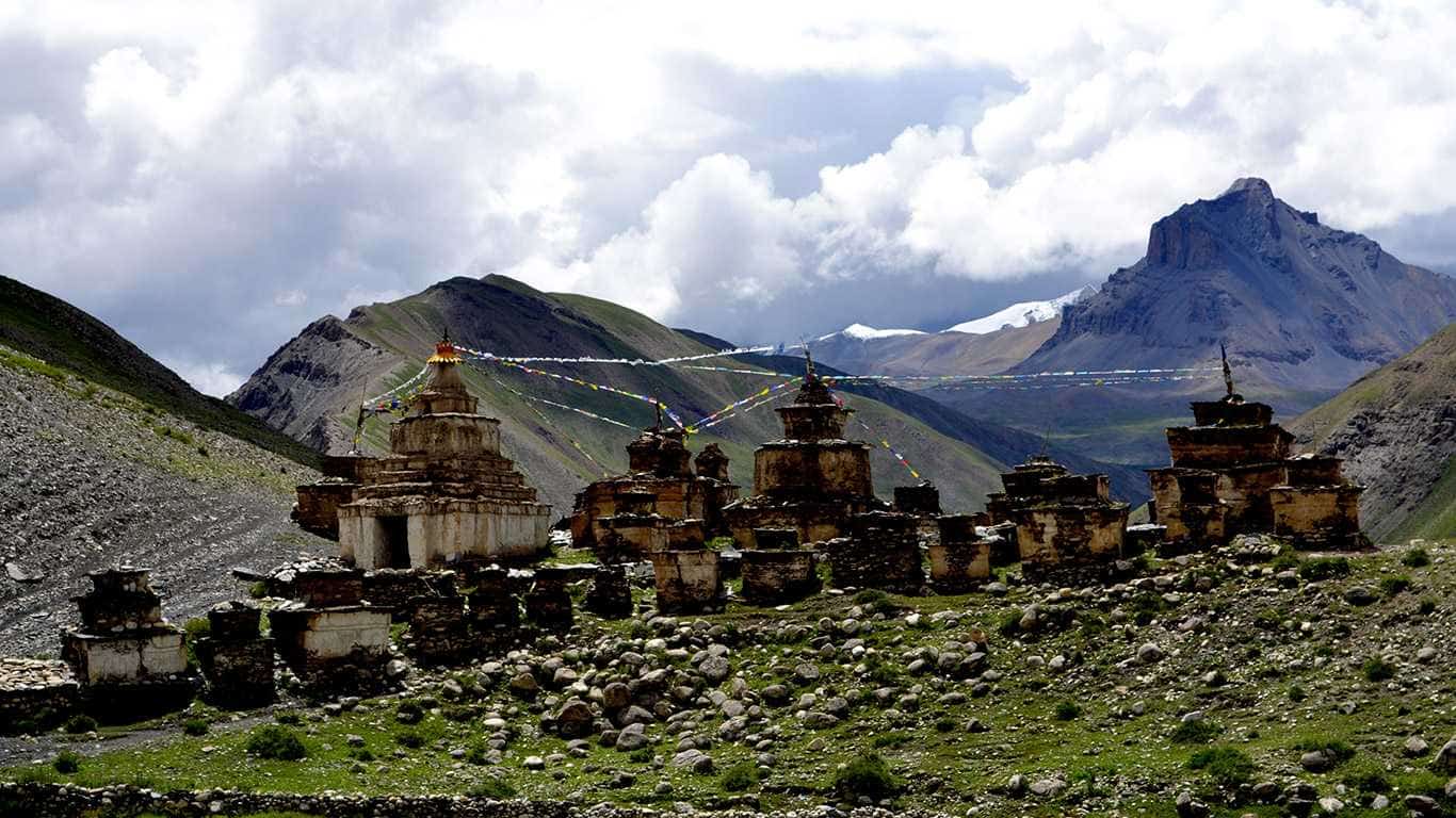
Tibetan Buddhism and the ancient Bon religion are mostly practiced here with immense spiritual faith. Shamanism remains a revered profession while the archaic ritual of Sky Burial is practiced. The Dolpo-Pas are polyamorous practicing polyandry for centuries, usually brothers of the same family marry a girl, mostly owing to its limited population yet having a vast geography.
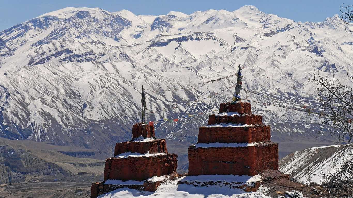
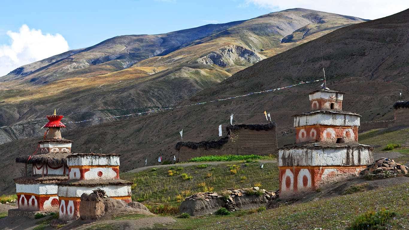
This land is the home to Shey Gompa and the Shey (Crystal) Mountain, the spiritual haven that hosts Shey festival taking place once every twelve years. Apart from that, visiting centuries-old monasteries like Yangjer, Dedhen Samtenling, and more is another highlight of Dolpo.
Dolpo Treks
Dolpo remains one of the most mythical places in Nepal. It is among the few places where Bon, an indigenous Tibetan culture, thrives. The indigenous Tibetan religion is Buddhism. Dolpo is also known for its remoteness. It’s a place few travelers venture to. The area remained under the radar until Peter Matthiessen published The Snow Leopard.
The remote Dolpo region is in the northwest of Nepal. It might be isolated from most parts of Nepal. Those who travelled to Dolpo have much to share with the world. The region rewards its visitors with ethereal landscapes and centuries-old Tibetan culture. Trekkers are greeted with pristine wilderness and valleys untouched by time.
The Dolpo region in Karnali Province borders Tibet to the north. Likewise, it falls under the jurisdiction of Dolpa District. Small fact: it’s the largest district in Nepal. The territory is split into two sections, Lower Dolpo and Upper Dolpo. The elevation of Dolpo starts at 1,525 meters. The Upper Dolpo has an altitude of 7,625 meters, the peak of Churen Himal. The coordinates for the Dolpo region are 28.8330° N, 83.2936° E.
Why Trek in the Dolpo Region?
The Dolpo region offers more than just treks. It is a cultural immersion for every traveler along its path. It is a pilgrimage into the heart of remote landscapes. Here’s why you should trek in the Dolpo region:
Preserved High-Altitude Civilization:
Explore ancient Tibetan culture thriving in Dolpo. The traditions have remained untouched for centuries.
People in Dolpo follow Bon and Tibetan Buddhism. Travel to centuries-old monasteries like Shey Gompa in the region.
Experience rituals, festivals, and spiritual practices rarely seen elsewhere in Nepal.
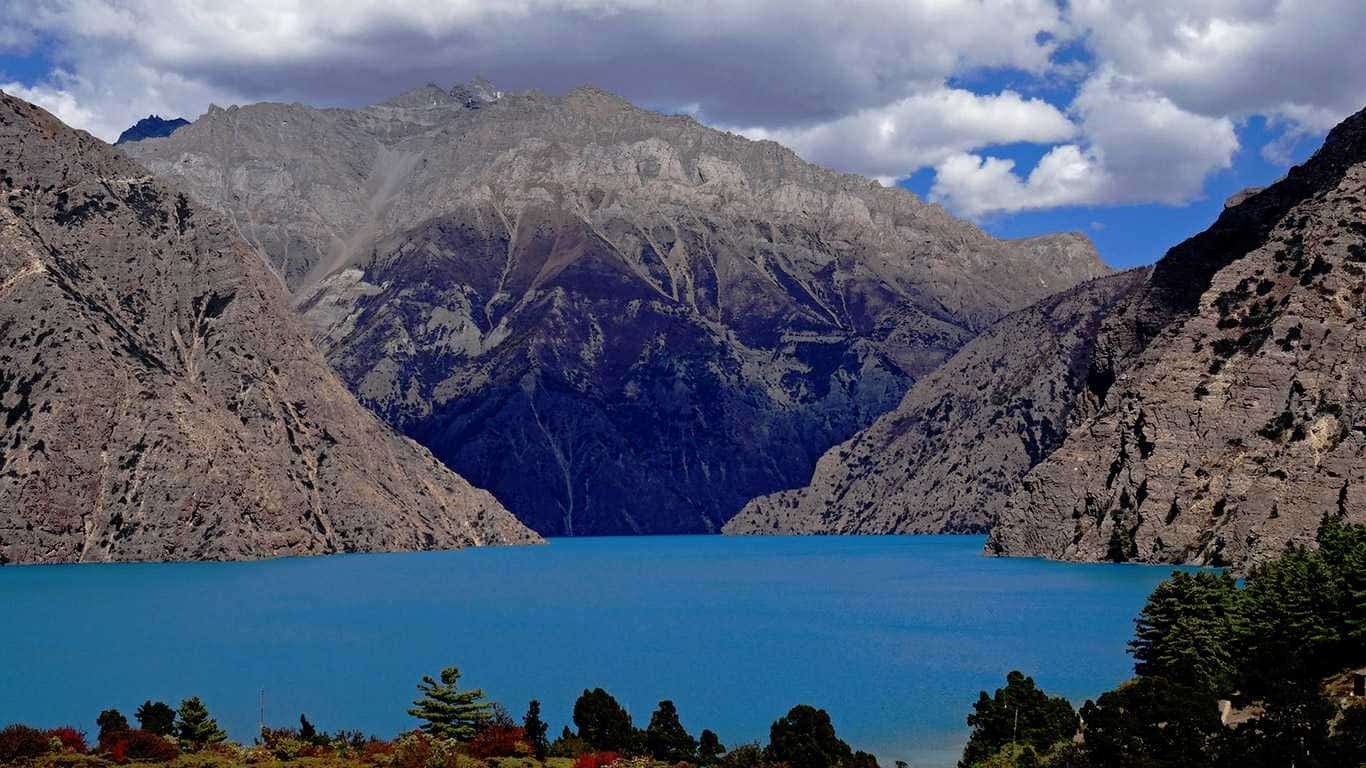
The natural wonder, Phoksundo Lake:
Visit Shey Phoksundo Lake at an elevation of 3,611.5 meters. It’s the deepest lake in Nepal, with a depth of 145 meters.
Phoksundo Lake is known for its striking turquoise colour. The stillness and mirror-like water further elevate its beauty.
Many cliffs and snow-capped mountains surround the lake. It’s a photographer’s paradise and a spiritual centrepiece.
High Mountain Passes and Remote Trails:
You can cross high-altitude passes like Kang La and Numa La Pass. Both passes are well over 5,000 meters.
The trails take you through isolated valleys and yak pastures. It also passes the ancient trade routes once used to reach Tibet.
The sense of vastness and silence is unmatched. It gives you solitude and a meditative trekking experience.
Unique Wildlife and Medicinal Flora:
Chance to encounter rare Himalayan wildlife:
Snow leopards (Tracked in Upper Dolpo, but very elusive)
Blue Sheep
Himalayan Griffons
Musk Deer
Wild-growing medicinal herbs: Yarsagumba (Cordyceps)
Off the Grid Adventure:
Less crowded than the Annapurna and Everest regions. You might not see another trekker for days.
No bustling villages or tourist infrastructure. You will only find quiet hamlets and nomadic camps.
The remoteness offers a personal and spiritual journey. The solitude is unmatched anywhere else in Nepal.
How to reach the Dolpo Region?
There are two ways to reach the Dolpo region from Kathmandu. You can take either connecting flights or travel by road. While you can find a direct flight to Dolpo at times, they are rare. Here’s a step-by-step guide to help you plan:
Connect Flights to Dolpo
Step 1. Fly to Nepalgunj from Kathmandu:
Buy a plane ticket to Nepalgunj at Tribhuvan International Airport or online
Reach TIA, board the plane
The flight takes 50 minutes to 1 hour to reach Nepalgunj
Cost: Approx. USD 135-150
Prices vary with airlines and the season
Step 2. Overnight Stay in Nepalgunj:
Unpredictable weather can cause delays or cancellations. So, it's best to stay overnight in Nepalgunj before connecting flights.
Hotels, lodges, and hostels are readily available in Nepalgunj.
Cost: NRP 1,000-4,000 (USD 10-30) a night.
Step 3. Fly from Nepalgunj to Juphal Airport in Dolpo
Book a ticket to Juphal Airport.
Juphal is the nearest airstrip to the Dolpo trekking route.
Flights in Spring and Autumn are more reliable.
The flight from Nepalgunj to Juphal takes around 35-45 minutes.
Cost: Approx. USD 190-200
Note: Flights are weather-dependent.
Step 4. Start Trekking from Juphal:
The flight from Nepalgunj lands in Juphal, Dolpa.
Start hiking to Dunai.
Duration of the hike: 2-3 hours.
By Road: Kathmandu to Dolpo
Step 1. Drive from Kathmandu to Nepalgunj or Surkhet:
You can book a ride with a bus, HiAce van, or hire a private jeep.
It goes from Kathmandu to Nepalgunj or Surkhet.
Cost:
Local Bus: NRP 1,800-2,500 (USD 15-30)
HiAce Van: NRP 2,200-2,500 (USD 25-30)
Jeep hire: NRP 25,000-35,000 (USD 195-265). Splits among passengers
Trip Duration: 12 to 16 hours by private vehicle. It takes up to 18 hours by bus.
Step 2. Continue to Jajarkot via Bheri Highway:
You can take a local bus, shared jeep, or hire a private jeep to reach Jajarkot.
You can book a seat in Nepalgunj.
Cost:
Local Bus: NPR 1,200-1,700 (USD 10-15)
Sofa Bus: NPR 2000-2250 (USD 16-18)
Shared Jeep: NPR 2,000-3,500 (USD 15-25)
Hired Private Jeep: NPR 15,000-25,000 (USD 110-195)
Trip Duration: 8 to 10 hours on rugged roads.
Step 3. Jeep Ride from Jajarkot to Dunai
Four-wheel drive vehicles are the only way we can travel to Dunai.
You can book a shared ride from Jajarkot to Dunai.
Cost:
Shared 4WD: NPR 3,000-6,000 (USD 25-50)
Private 4WD Hire: NPR 15,000-25,000 (USD 110-195)
Trip Duration: 1-2 days
Distance: Approximately 118 Kilometres
Winding and bumpy route
We recommend finding a local driver familiar with the terrain
Road still under construction
Final stretch of taking a snail's pace
Step 4. Begin your trek from Dunai
You begin your trek in Dolpo in Dunai.
Dunai has an elevation of 2,140 meters.
Final Tips:
Flight to Juphal and trekking to Dolpo is the fastest route.
Traveling by road can be flexible and adventurous, but it’s longer and rougher.
Always check local weather reports and travel advisories before departure.
Culture and community are found in the Dolpo Region.
The Dolpo region is a treasure trove of cultural and spiritual ways. The societal roots in the territory predate Buddhism. Likewise, the tradition in Dolpo remains preserved. Many villagers still practice the Bon religion and rituals. Similarly, the centuries-old monasteries, such as Shey Gompa, are a centre of spirituality.
Dolpo is the home of the Dolpo-Pa people, a Tibetan ethnic group. Most know them as Bhotias. They primarily live an agro-pastoral life. Dolpo-Pa mostly relies on a combination of farming and animal husbandry. Yaks and sheep are the primary livestock in Dolpo for their diet. Similarly, the people need the wool from these animals to survive the cold.
They have preserved their traditions. You will find unique customs and social structures in Dolpo. One of their unique practices is polyandrous marriage. The women in the Dolpo-Pa community can take multiple husbands. Besides that, the people of Upper Dolpo are known for their sky burials.
In lower Dolpo, communities of Brahmin, Chhetri, and Magars can be found. Smaller communities of Gurung, Sherpa, and other ethnic groups live in Lower Dolpa. The people of Dolpo face harsh conditions. Yet, they remain warm, deeply spiritual, and self-reliant.
One of the biggest festivals celebrated in the Dolpo region is the Shey festival. It's celebrated every twelve years. Likewise, the last one was held from September 1 to 4, 2024. The next Shey festival will be in the Tibetan lunar calendar’s Dragon year, 2036.
Varying Landscapes in Dolpo
The Dolpo region is a land where opposites harmoniously coexist. You’ll find lush alpine forests and barren cliffs around the territory. You’ll go through verdant river valleys one day. The next day, you’re navigating the ice-laced mountain passes rising above 5,000 meters. The crowning jewel of the Dolpo region is Phoksundo Lake.
Popular Trekking Packages in the Dolpo Region
Phoksundo Lake Trek
Find unique landscapes and exotic culture on the Phoksundo Lake Trek package. Travel to the heart of the Dolpo region. Likewise, you can find some of the Himalayan fauna during the trek. And here’s what you can expect from this package:
Duration: 12 Days
Max Altitude: Ringmo Village 3,460
Coordinates: 29.1701° N, 82.9360° E
Difficulty: Beginner-Friendly Trekking
Trip Start: Kathmandu
Trip End: Kathmandu
Accommodation: Tea Houses & Hotels
Meals: Included in the package
Temperature: 13°C (55°F) Day / -10°C (14°F) Night
Group Size: 2-16
Best Season: Spring/Autumn/Winter
Upper Dolpo to Mustang Trek
Trek through the most remote and undeveloped trails. Travel across Shey Phoksundo National Park. Discover a wild and incredible diversity of flora and fauna. Journey through the place where The Caravan was filmed. Here’s what you can expect from the Upper Dolpo to Mustang Trek package:
Duration: 27 Days
Max Altitude: Nangdola High Camp 5,350
Coordinates: 29.280379° N, 82.915274° E
Difficulty: Moderate Trekking
Trip Start: Kathmandu
Trip End: Kathmandu
Accommodation: Tea Houses & Hotels
Meals: Included in the package
Temperature: 13°C (55°F) Day / -10°C (14°F) Night
Group Size: 2-16
Best Season: Spring/Autumn
Upper Dolpo Trek
Try trekking through Nepal’s largest national park, Shey Phoksundo National Park. Find a variety of flora and fauna during the trek. Experience the exotic views of Lake Phoksundo. Learn about the locals and Bon religion. Here’s what you can expect from the Upper Dolpo Trek package:
Duration: 27 Days
Max Altitude: 5,151 Meters
Coordinates: 29.352703° N, 82.965359° E
Difficulty: Intermediate Trekking
Trip Start: Kathmandu
Trip End: Kathmandu
Accommodation: Tea Houses & Hotels
Meals: Included in the package
Temperature: 13°C (55°F) Day / -10°C (14°F) Night
Group Size: 2-16
Best Season: Spring/Autumn
Mystic Dolpo trek via Jumla GHT Route
Travel through off-the-beaten-path in the far West. Experience the untouched Himalayan culture. Trek through Nepal’s biggest national park, Shay Phoksundo National Park. Find a well-preserved ecosystem during your journey. Here’s what you can expect from the Mystic Dolpo trek via Jumla GHT Route package:
Duration: 24 Days
Max Altitude: Numa La Pass 5,360
Coordinates:
Difficulty: Intermediate Trekking
Trip Start: Kathmandu
Trip End: Kathmandu
Accommodation: Tea Houses & Hotels
Meals: Included in the package
Temperature: 13°C (55°F) Day / -10°C (14°F) Night
Group Size: 2-16
Best Season: Spring/Autumn
Upper Dolpo to Humla Simikot Trek
Experience the most isolated trekking trails. Search for Yarsagumba in the Upper Dolpo. Find a majestic view of Nepal’s deepest Lake. Here’s what you can expect from the Upper Dolpo to Humla Simikot Trek package.
Duration: 44 Days
Max Altitude: Nyingma Gyanzen La Pass 5,563 Meters
Coordinates: 29.9863° N, 81.8334° E
Difficulty: Moderate Trekking
Trip Start: Kathmandu
Trip End: Kathmandu
Accommodation: Tea Houses & Hotels
Meals: Included in the package
Temperature: 13°C (55°F) Day / -10°C (14°F) Night
Group Size: 2-16
Best Season: Spring/Autumn
Upper Dolpo to Jomsom Trek
Explore the UNESCO heritage sites of Kathmandu. Then visit the exotic Phoksundo Lake. Enjoy the breathtaking views of the sweeping Himalayas and mountains. Discover new cultures and traditions. Here’s what you can expect from the Upper Dolpo to Jomsom Trek package:
Duration: 26 Days
Max Altitude: 5,550 Meters
Coordinates: 28.7746° N, 83.7730° E
Difficulty: Intermediate Trekking
Trip Start: Kathmandu
Trip End: Kathmandu
Accommodation: Tea Houses & Hotels
Meals: Included in the package
Temperature: 13°C (55°F) Day / -10°C (14°F) Night
Group Size: 2-16
Best Season: Spring/Autumn
Difficulty levels in the Dolpo Region
You can find different trekking experiences in the Dolpo region. You might travel along peaceful lakesides or explore extreme high-altitude areas. Trekkers can choose from beginner-friendly routes to extreme climbs in the Dolpo region. Let’s break down the difficulty levels to help you find the trip that fits your ability.
Beginner-Friendly Treks:
Shey Phoksundo Lake Trek:
Trek duration: 10 to 12 days.
Ideal for trekkers with decent altitude experience.
Gradual trails below 4,000 meters, reducing the risks of altitude sickness.
Offers a mesmerizing view of Phoksundo Lake.
Accommodations range from basic teahouses to tented camping.
Great first taste of Dolpo’s beauty without committing to extreme conditions.
Moderate Treks:
Mystic Dolpo trek via Jumla GHT Route:
Trek duration: 24 Days
Ideal for trekkers with high-altitude experience.
Involves rough, uneven terrains and high altitudes.
It offers hypnotizing views of the mountains, along with flora and fauna
Accommodations range from basic teahouses and tented camps.
Best for those wanting to face the full challenge of the Himalayan wilderness.
Intermediate Treks
Upper Dolpo Trek:
Trek duration: 27 Days
Trekkers need a serious commitment to take on these treks.
It involves many high passes, with a maximum elevation of 5,151 meters.
Accommodations are limited to basic teahouses or tented camps.
Multi-day camping in wilderness areas with few to no infrastructures.
Rewards for the trek:
Exploring Shey Gompa, experiencing the culture, and the unbeatable views of Kang Taiga.
Hard Treks
Upper Dolpo to Jomsom Trek:
Trek duration: 26 Days
Best for experienced trekkers wanting to test their endurance.
The trek includes steeper ascents, longer trekking hours, and fewer rest points.
Some trails cross lesser-known high passes. The elevations can go up from 4,800 meters to 5,550 meters.
Requires mental resilience and logistical flexibility.
It’s one of the Great Himalayan Trails (GHT)
Extreme Treks
Trek duration: 28 Days
Max elevation: Numala Pass 5,309
The trek hours are long. Most days, you’ll be trekking for 7-8 hours.
Travel through charming forests on the least explored trails.
Limited choices in accommodations. You’ll rest in basic teahouses or tented camps.
Explore the Jewel of Dolpo, Phoksundo Lake.
Best Time to Be in the Dolpo Region: Seasons and Temperatures
Visiting the Dolpo region is like going back in time. The experience itself can be called timeless. To enjoy the journey in Dolpo, selecting the right season is key. At the right time, you can experience the blooming flowers or frozen winter silence. Here’s what you should know about the best time to be in the Dolpo region.
Spring (March to May)
Spring in Dolpo comes to life with renewal. The lower valleys burst into life with vibrant rhododendrons and alpine flowers. The skies remain clear and pleasant during Spring. But the high passes still hold lingering snow. Spring also offers cultural immersion in the Dolpo region.
The weather during Spring in Dolpo is welcoming. During the day, the temperatures range from 10°C to 20°C. And at night, the areas see a drop to -5°C to 0°C. This proved, spring is the best season to trek in the Dolpo region.
Summer (June to August)
Monsoon and Summer come hand in hand in Nepal. Much of the country is drenched with rain. Surprisingly, the Upper Dolpo region stays dry and accessible in summer. On the other hand, Lower Dolpo can be muddy and house some unwelcome guests, leeches.
Find a mild temperature in the entire Dolpo region during summer. It can reach around 22°C during the day. Likewise, it can reach zero at night. But mostly stay a mild 8°C at nighttime.
Autumn (September to November)
Autumn is the second popular trekking season in Nepal. After summer and monsoon end, the clouds clear, making way for blue sky. Trekkers can experience a stunning view of mountains and peaks. Autumn is the best time for photographers to visit the isolated region.
After the summer and monsoon end, trekkers experience calmer weather. The daytime temperature usually sits at 18°C. But at night, it can get cold. Temperatures can range from 10°C to -11°C.
Winter (December to February)
Winter in Dolpo offers solitude and snow-blanketed trails. Trekkers can find magical yet challenging experiences. High passes are impassable, and most routes to Upper Dolpo remain closed. But Lower Dolpo remains open for travelers. But facilities are limited, and nights can get bitterly cold.
The daytime temperature in Lower Dolpo is cold. The area’s temp ranges from -10°C to 5°C during the day. Similarly, nights are bitterly cold during winter. It can drop to -15°C to -20°C or lower.
Accommodation and Food Available in the Dolpo Region
Infrastructures are underdeveloped in the Dolpo region. As such, you won’t find the Annapurna or Everest region level of accommodations. With the remoteness, there’s a separate charm staying at a teahouse or even homestays. You trade convenience for authenticity.
A high-altitude life shaped the cuisine found in the Dolpo region. You’ll find hearty soups and foods preserved with ancient methods. Meals are prepared using fresh and local ingredients. Food in Dolpo offers the taste of resilience in every bite.
Accommodation and Facilities in the Dolpo Region
The Dolpo region has limited infrastructure given its remoteness. But you can still find basic options along the path. Here’s what you can expect on the trails of Dolpo:
Teahouses:
Simple teahouses are available mostly in Lower Dolpo. Most are on the way to Phoksundo Lake and the Dunai trail. You can still find time in Upper Dolpo, but fewer in numbers. They offer the basics such as bedding, dal bhat meal, and hot tea. They don’t have Wi-Fi or hot showers.
Hotels:
Hotels are mostly established in Nepalgunj. But you can occasionally find them in Dunai. These places are mostly used before the trek begins. Or during the overnight stay at Nepalgunj.
Lodges:
Some of the popular villages in Ringmo and Saldang have lodges. They are more comfortable than teahouses. But the facilities remain basic. Lodges in Dolpo have thick foam mattresses, shared bathrooms, and yak dung heating.
Homestays:
Homestays are the only option in Upper Dolpo. They are also the richest in cultural immersion. You stay with local families in their stone-walled houses. You’ll eat what they eat. It’s a rare opportunity to experience the Tibetan-influenced mountain life.
Foods that are only found in the Dolpo Region
The remoteness of the territory forced the people to be practical. It also shows in the food they eat. All cuisine in the Dolpo region is practical and meant for the Himalayan life.
Must-try Foods in Dolpo Region
Thenthuk:
It’s a hearty Tibetan noodle soup. The noodle is hand-pulled dough. And the soups are usually dried vegetables or yak meat. Thenthuk is perfect for the cold weather.
Tsampa:
A staple Himalayan food. Tsampa is made from roasted barley flour. It's mostly served with butter tea or water, making it dense. Tsampa is an energizing meal for long treks.
Yak Butter & Cheese:
Yak butter & cheese are made in many households. It's high in fat and calories, making it perfect fuel for high-altitude trekking.
Sukuti & Potatoes:
Sukuti is a form of dried meat. Most dried meat in Dolpo is yak or goat meat. The mix of dried meat with locally grown potatoes. It forms a protein-rich and filling combination. It’s commonly served during winter and in the highlands.
Drinks to Try in Dolpo Region
Po Cha (Butter tea):
Po Cha is a staple drink in the Himalayas. It’s salty, oily tea made from yak butter, tea leaf, and salt. It’s a lifesaver in the cold. It offers hydration and calories.
Chyang:
A mildly alcoholic drink made from fermented millet, rice, or barley. It’s also known as rice beer. It's mostly served during social gatherings. And it’s also used for rituals.
Seabuckthorn Juice:
It’s found in some valleys during late summer and early autumn. The juice is rich in vitamin C. It has a refreshing, tangy flavour.
Final Note:
Luxury is off the table while you are in Dolpo. The authenticity of Dolpo is in every bowl of soup. Trekkers must prepare for rustic conditions for their trip in the Dolpo region. And you leave with a deeper connection with the land and the people.
What Permits Are Required for Trekking in the Dolpo Region?
The Dolpo region is a conserved and protected area. As such, trekkers must obtain many permits. The region splits into two halves. We have Lower Dolpo and Upper Dolpo. Each halves have different permit requirements, costs, and restrictions.
The types of Permits needed:
Upper Dolpo Restricted Area Permit (RAP):
Purpose:
Required to enter the Upper Dolpo region. Upper Dolpo is a highly regulated area; it has a perverse culture and environment.
Cost:
USD 500 per person for the first 10 days.
USD 50 a person per additional day.
Where to Get it:
Department of Immigration, Kathmandu
Must apply through a registered trekking agency.
Lower Dolpo Restricted Area Permit (RAP):
Purpose:
Required for treks in the Lower Dolpo region. It also falls under a restricted area.
Cost:
USD 20 Per Week and Per Person
Where to Get it:
Department of Immigration, Kathmandu
Must apply through a registered trekking agency
Shey Phoksundo National Park Entry Permit:
Purpose:
It grants entry into the Shey Phoksundo National Park. The national park covers Lower and Upper Dolpo.
Cost:
NPR: 3,000 per person (Approx. 25 USD)
Where to Get it:
Nepal Tourism Board (NTB): Kathmandu or Pokhara
Can be arranged through a trekking agency
TIMS Card (Trekkers’ Information Management System)
Purpose:
Tracks and records foreign trekkers. It’s for safety and rescue operations.
Cost:
NPR 2,000 for Individual Trekkers (Approx. 15 USD)
NPR 1,000 for a group of Trekkers (Approx. 10 USD)
NPR 600 for an Individual SAARC citizen
NPR 300 for a group of SAARC citizens
For Frequently Asked Questions (FAQs) About Dolpo Treks, follow our blog post.